Switch from GR4J to GR6J lumped hydrological model to produce ESP forecasts for the UK Hydrological Outlook (UKHO)
The GR4J (Génie Rural à 4 paramètres Journalier) and GR6J (Génie Rural à 6 paramètres Journalier) models come from a suite of hydrological models provided in the airGR modelling suite (Coron et al., 2021) for the R software program. GR6J (Pushpalatha et al., 2011) is a six-parameter variant of the GR modelling suite that was developed to improve low-flow simulation and groundwater exchange compared to GR4J which has only four parameters. Notably, GR6J has gained increasing popularity in UK water resources applications. To align with industry norms in UK water resource management, we have chosen to shift from using the GR4J model, which was employed for ESP forecasting until September 2023, to using the GR6J model starting from October 2023.
Hannaford et al. (2023) showed that GR6J outperformed GR4J for a range of performance metrics for a set of 200 catchments across the UK. Employing the methodology outlined in Harrigan et al. (2018), we assessed how this model transition affected forecasting skill when generating river flow forecasts through the ESP method for the 314 catchments used in the UKHO. The assessment employed the Continuous Ranked Probability Skill Score (CRPSS) as the forecasting skill metric. Results indicate that, for most regions and lead times, the differences in skill are marginal, with mean differences of less than 0.03 (Figure 1). We therefore anticipate this transition will have a minimal impact on users' experience with these forecasts. However, four catchments (27032, 28039, 28060, and 42004, as indicated by darker red triangles on the maps in Figure 3) exhibit a deterioration in skill when switching to GR6J, and investigations are currently underway to address this issue with these specific catchments. We would remind users that the magnitude of skill is represented by the size of the dot on the forecast map displayed on the UKHO portal, reflecting our confidence in the issued forecasts.
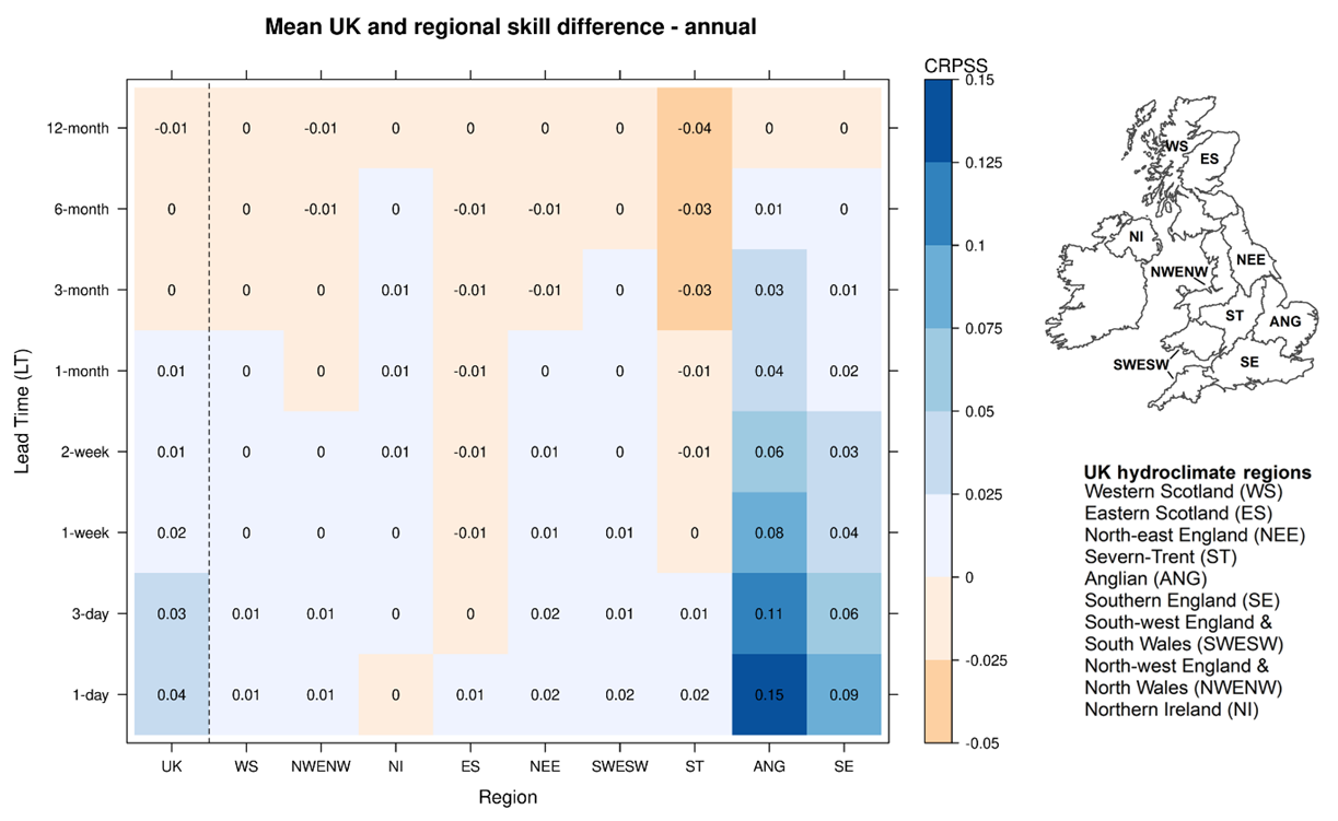 Figure 1: Change in forecasting skill (CRPSS) at different lead time when transitioning from GR4J to GR6J to produce ESP forecasts in the different UK hydroclimate regions. Blue signifies improved forecast skill with GR6J compared to GR4J, while orange shades represent the reverse.
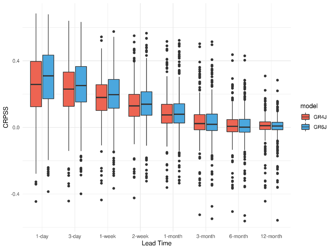 Figure 2: Boxplots showing the range of CRPSS for all catchments used in the UKHO at different leadtimes in ESP forecasts generated using GR4J (in red) and GR6J (in blue).
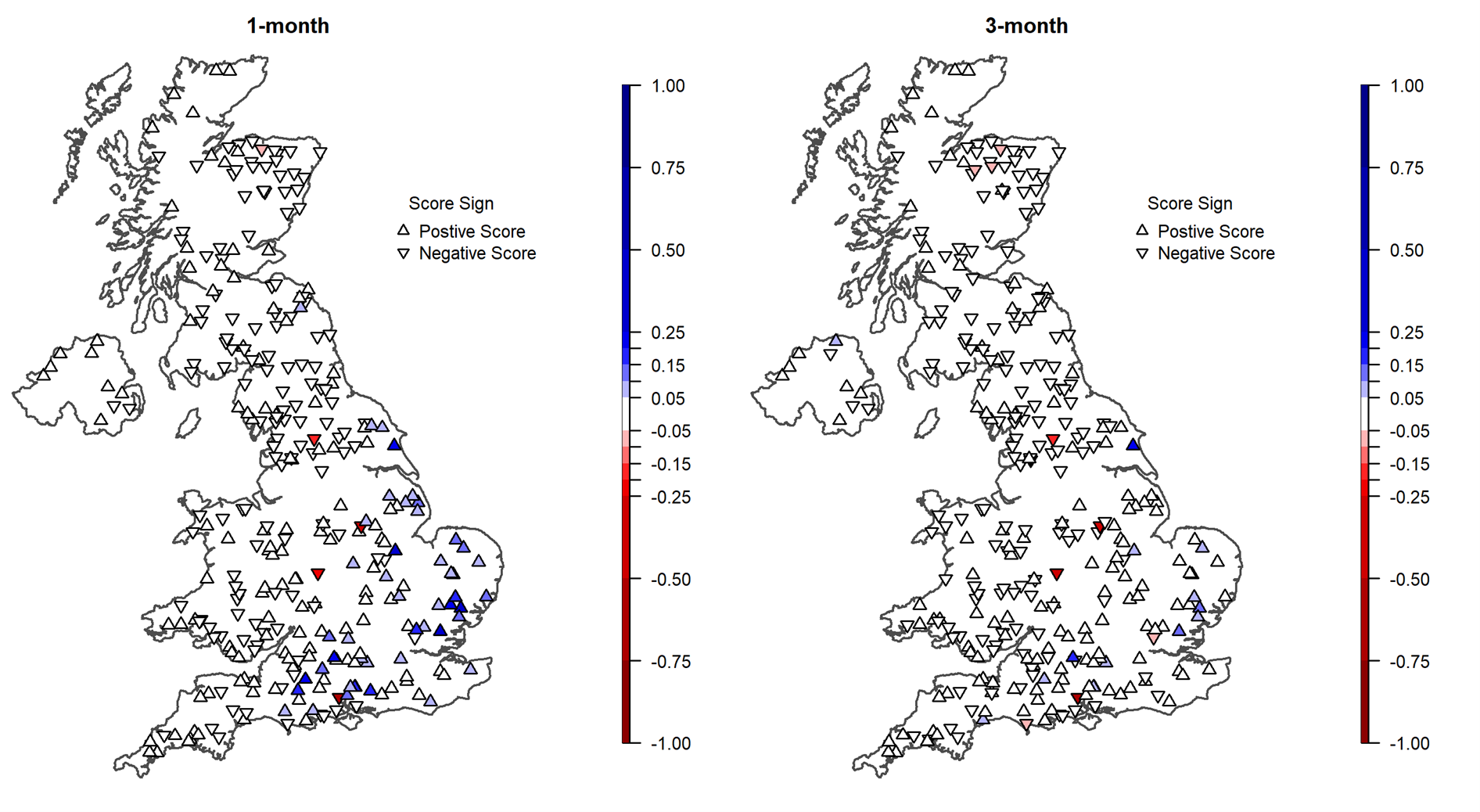 Figure 3: Map of difference in skill (CRPSS) between ESP forecasts generated using GR6J and GR4J at (left) 1-month lead time and (right) 3-month lead time. Blue shades signify improved forecast skill with GR6J compared to GR4J, red shades represent the reverse, while white signifies negligeable differences.
References:
Coron, L., Delaigue, O., Thirel, G., Dorchies, D., Perrin, C., and Michel, C.: airGR: Suite of GR Hydrological Models for Precipitation-Runoff Modelling, R package version 1.6.12, Recherche Data Gouv [code], https://doi.org/10.15454/EX11NA, 2021
Hannaford, J., Mackay, J. D., Ascott, M., Bell, V. A., Chitson, T., Cole, S., Counsell, C., Durant, M., Jackson, C. R., Kay, A. L., Lane, R. A., Mansour, M., Moore, R., Parry, S., Rudd, A. C., Simpson, M., Facer-Childs, K., Turner, S., Wallbank, J. R., Wells, S., and Wilcox, A.: The enhanced future Flows and Groundwater dataset: development and evaluation of nationally consistent hydrological projections based on UKCP18, Earth Syst. Sci. Data, 15, 2391–2415, https://doi.org/10.5194/essd-15-2391-2023, 2023.
Harrigan, S., Prudhomme, C., Parry, S., Smith, K., and Tanguy, M.: Benchmarking ensemble streamflow prediction skill in the UK, Hydrol. Earth Syst. Sci., 22, 2023–2039, https://doi.org/10.5194/hess-22-2023-2018, 2018.
Pushpalatha, R., Perrin, C., Le Moine, N., Mathevet, T., and Andréassian, V. A.: Downward structural sensitivity analysis of hydrological models to improve low-flow simulation, J. Hydrol., 411, 66–76, https://doi.org/10.1016/j.jhydrol.2011.09.034, 2011.